
Serendip is an independent site partnering with faculty at multiple colleges and universities around the world. Happy exploring!
Science and a Sense of Place: Session One

Science and a Sense of Place
(July 23-August 3, 2007)
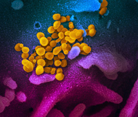
 Can you tell, from looking at this, what it is?
![]()
Can you tell, from looking at this, where it is?
Can you read its history?
not just public art, but a
democratic , creative, community-based process
I. Introduction: doing science "with a sense of place" will raise questions
- about what it means to "do science" /about what science IS
(cf. the idea of developing an awareness of one's own particular location with traditional ideal: Thomas Nagel on "the view from nowhere"...)
- about the environment
- about culture
- about economics, and race, and social justice....
(what does it mean to be bused out of your neighborhood?
what does it mean to be kept in it?)
- about science IN society
- about where we are in the world
- about what the world looks like
- about how we organize the stories we tell about the world.
(cf. the idea of developing an awareness of one's own particular location with traditional ideal: Thomas Nagel on "the view from nowhere"...)
(what does it mean to be bused out of your neighborhood?
what does it mean to be kept in it?)


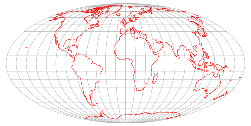
II. Map-making is a good exercise to demonstrate this.
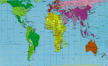
"The earth is round. The challenge of any world map
is to represent a round earth on a flat surface.
There are literally thousands of map projections.
Each has certain strengths and corresponding weaknesses.
Choosing among them is an exercise in values clarification:
you have to decide what's important to you."
- draw a map locating yourself in the world
- use your map to introduce yourself to us: where are you from?
- compare maps: what were our different points of reference?
- what various reference frames did we draw on?
- did we omit anything important?
- what do our maps say about how we understand the world?
- what reference frames make the most sense to your students?
- how might you be able to enlarge their sense of place?
- pair up w/ someone located differently, to co-construct a new map of the world: how can you connect your different reference frames?
- what did you learn, by re-drawing a map with someone else? how can you negotiate reference frames that are not shared?
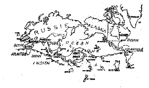
"In this map, the Pacific Ocean is central,
the United States does not exist....
Mexico, Russia, Alaska, China, and Labrador
have strong representations."
Coffee Break
III. coursekeeping
- logistics: daily/weekly schedule review/parking/sign-ins, etc.
-
each morning, a different guest facilitator will share her own frame of reference w/ you, show you how do "science with a sense of place," invite you to design something similar for your own classroom (and the place surrounding it)
- very expansive definition of "sense of place"--tomorrow morning: psychologist and provost Kim Cassidy about the "place that is the self"
- each afternoon of the institute
- comment on the morning's session
-
- chose a topic that interests you, and create a page in your blog archiving the research you have done
- chose a topic that interests you, and create a page in your blog archiving the research you have done
- final performances about your
relation to the material presented and researched here
- on our last day, take ten minutes to share your most interesting discoveries and thoughts with us
by September 1st, put together a written proposal for educational supplies and materials to put some new/expanded curriculum into practice.
-
IV. Enlarging our map of the worldV. Exploring the Global: "Where Do Humans Congregate?"
VI. dual conception of the Institute: localizing, not parochializing
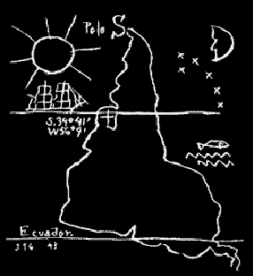
Uruguayan modernist Joaquín Torres-García,
The Upside-down Map (1943).
"A centerpiece in the history of Latin American efforts
at reclaiming themselves in a world vision.
Torres-García placed the South Pole at the top of the earth,
thereby suggesting a visual affirmation of the
importance of the continent, and in an effort to
present a pure revision of the world. He was also
interested in presenting to the world a
modern "school of the south..."So: what have you learned (so far)?
How might you use any of this in your own classroom?Before you go: post in the forum BELOW what you found useful from today's session: what can you apply to your own classroom, or you own thinking about teaching? what questions do you have, that you'd like us to address?And don't leave til we get your picture! - on our last day, take ten minutes to share your most interesting discoveries and thoughts with us
-
Remote Ready Biology Learning Activities
Remote Ready Biology Learning Activities has 50 remote-ready activities, which work for either your classroom or remote teaching.
What's New? Subscribe to Serendip Studio
A Random Walk
New Topics
-
10 weeks 6 days ago
-
11 weeks 12 hours ago
-
11 weeks 3 days ago
-
11 weeks 3 days ago
-
11 weeks 3 days ago

Comments
Thoughts at the end of the day
I wasn't sure what to expect when I signed up for this two-week session, but I think it's going to provide a lot of "food for thought" as our group interacts, discusses, and shares experiences. I expected to feel tired at the end of the day, but I left class invigorated and looking forward to Tuesday.
The mapping activities were wonderful ways to get to learn a little bit about each other in a comfortable, creative way. I can adapt the activity and try it with my 1st graders in the fall. I was surprised how much I didn't know about biomes. There are examples of all 5 zones of the deciduous forest on my school grounds!
I really appreciated having a block of time to search the Google Map & National Geographic sites. There never seems to be enough time to find additional resources.
session one
Session 1 Commentary