
Serendip is an independent site partnering with faculty at multiple colleges and universities around the world. Happy exploring!
Borders

When you live in a suburb of Cincinnati, you orient yourself by the highways. Get on I-71 and head south into the city. Or you could take a detour on I-275 and take the long way, avoiding the city itself as you drive into Kentucky. However, if you head just a little bit east on 275, you’ll hit Terrace Park, while west will get you to Sharon Woods. Anywhere North and you’re probably heading the wrong way because it’s just cornfields until you hit Columbus an hour and a half later. Let’s stick to the simple things, though, and head South, straight into Cincinnati.
But where does Cincinnati start?
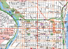
Philadelphia has a border, a river on either side, and a clear, at least from this student’s point of view, delineation between the city and the surrounding areas. Much like the maps we built in class, even detailed published maps use the Schuylkill and the Delaware as the boundaries of the map:
Of course the exact border might change depending on an individual’s approach to the city, whether car, train, bus, or even walking, but that is the nature of boundaries in cities: they constantly shift as the neighborhoods and roads morph over time. In Philadelphia’s case, the subway and other public transit stations probably have a great influence on how commuters see the borders of the city. Indeed, city boundaries are not just concrete lines, but they change both over time and from person to person. Cincinnati is a city that takes this concept way too seriously. It is nearly impossible to find a single, solid ‘boundary’ for Cincinnati. Sure, you can probably try to point out the Ohio River dividing Kentucky and Ohio as some sort of landmark, but even that’s not particularly effective. The city across the river from Ohio, which is technically called Newport, is essentially an extension of Cincinnati. There’s a walking bridge across the water and celebrations and gatherings that span both sides. They are integrally linked socio-economically to the point that only locals would be able to tell them apart. The Northern border of Cincinnati is even more debatable; ask a local (I’m the obvious candidate in this situation), and they might say that the Taft exit off of I-71 is the first exit that will get you into the city. It has the major regional hospitals and a branch of the city’s university, but even that is not the heart of the city. In order to reach what most people would call “downtown”, the hustle and bustle of tall metal buildings and a distinct lack of greenery, you have to travel at least four more miles south. Others could argue that the city extends north of this seemingly arbitrary line to incorporate the largest, oldest, and most famous neighborhoods in the area. Indeed, Cincinnati is not much of a robust cultural and economic center without these neighborhoods included; they contain most of the local restaurants, the small, privately-owned shops, most of the city’s schools, and a lot of the cultural centers. The statistics on the region are most significant here when you realize that the city of Cincinnati (as in the downtown region of concrete blocks and skyscrapers) only has 300,000 residents whereas the whole metropolitan area, which includes all of those neighborhoods has 2.1 million people. Compare Cincinnati to Philadelphia and you see the real importance of this; Philly has 1.5 million people in its downtown region and 6 million in the entire area, which means that a quarter of the population of Philadelphia lives in downtown whereas only a seventh of Cincinnati’s population does the same. Cincinnati cannot exist as a city independent of the large neighborhoods that might be considered by some as ‘outside of city limits’. To simplify: Cincinnati is suburbia with a mini-metropolis in the middle, while Philadelphia is a towering metropolis surrounded by suburbia.
However, they are such different cities that a comparison to find out which one is the ‘better’ city is unfair to both of them. It’s like trying to decide which one’s better: A giant panda or a red panda. They both are labelled as pandas, they both share some of the most obvious features (four legs, snouts protruding from rounded heads, and circular ears stuck on top), but they are two entirely different species. They do not even belong to the same family and are only distantly related. The same is true of cities because they are each their own separate and unrelated entities. It seems so easy and simple to call Philadelphia the better city because it’s bigger, grander, more cultured or some other such nonsense, but for every massive market like Reading Terminal, Cincinnati has a Findlay market. For every history museum snug on the parkway, Cincinnati has Union Terminal Museum Center. For every Philly cheesesteak cart, Cincinnati has a Skyline chili. For every Rittenhouse Square, a Fountain Square. You want to compare size? The Public Library of Cincinnati has more books than Philadelphia’s Public library even though Philly is three times the size of Cincinnati. Size means nothing, particularly among two cities that are fundamentally different. Cincinnatians don’t go into downtown to meet at a café and chat with friends, they go five miles North to Hyde Park and wander down to the Coffee Emporium nestled among all of the neighborhood’s free-standing houses. Not to say that Cincinnati does not have its pitfalls: there is no public transportation system to speak of, but that is just one more thing that makes the city what it is. I’m no urban theorist, but without public transportation, everyone needs to independently commute, which means that everyone has cars. That is one of the reasons the city is so spread out among its suburban neighborhoods, because everyone has to commute anyways, so they tend to live farther away in a balance between the smaller population density and longer commute. Philadelphia on the other hand has the wonderful SEPTA, which is beloved of all car-less college students and shuttles thousands of people to work every day.
Now I know it seems circular to make an argument against comparisons by doing one myself, but the point is that the differences (e.g. population size, restaurants, types of museums, etc.) do not make one city better than the other, but simply makes them different. Furthermore, the identity of a city is constantly morphing, building upon itself, recreating itself using the incessantly changing people that live both within and without its limits. The people are unique and the cities that house them are unique. As I return home to Cincinnati tomorrow, I take back with me the knowledge of the city not just as a metal and concrete, but as a living creature capable of extraordinary things.
Philadelphia County, Pennsylvania. United States Census Bureau, n.d. Web. 19 Dec. 2013. <http://quickfacts.census.gov/qfd/states/42/42101.html>.
Road Map of Philadelphia. AccessMaps.com, 2007. Web. 19 Dec. 2013. <http://www.aaccessmaps.com/show/map/us/pa/philadelphia_overall>/.
Thomas, G S. Census: Cincinnati 57th-largest U.S. city. Cincinnati Business Courier, n.d. Web. 19 Dec. 2013. <http://www.bizjournals.com/cincinnati/stories/2010/06/21/daily22.html>.
Remote Ready Biology Learning Activities

Remote Ready Biology Learning Activities has 50 remote-ready activities, which work for either your classroom or remote teaching.
What's New? Subscribe to Serendip Studio
Recent Group Comments
-
artlily (guest)
-
Sources Correctionnightowl guest (guest)
-
Sourcesnightowl guest (guest)
-
Not Hannah HochSerendip Visitor (guest)
-
DisclaimerPhoenix
-
(No subject)Jessica Bernal
-
(No subject)Jessica Bernal
-
And for play in the city2, ICathy Zhou
-
Where's the "like" button.mlord
-
Source Editnightowl
Recent Group Posts
A Random Walk
New Topics
-
11 weeks 59 min ago
-
11 weeks 21 hours ago
-
11 weeks 4 days ago
-
11 weeks 4 days ago
-
11 weeks 4 days ago
