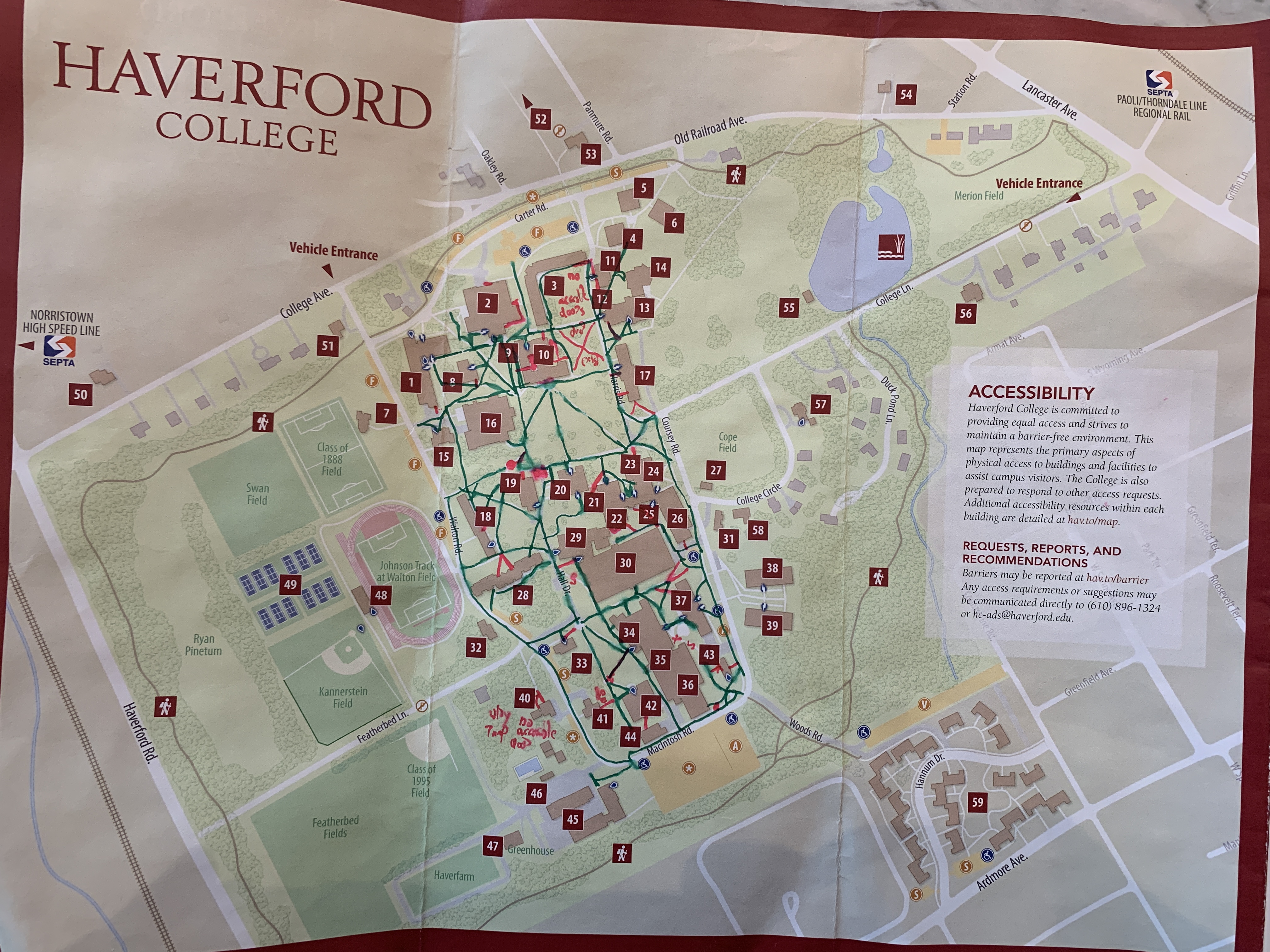
March 13, 2023 - 21:07

Attached is a link to my Midterm Project About Reworking Haverford's Map!
//docs.google.com/document/d/1ZRGDfawkBxwwvWtnm5OxEM3-5imd2pgdxt_MjwUSxEY/edit?usp=sharing
Please reach out if you have any questions or find any inacessible paths not currently shown on the map!
Another copy of the drawn map is also attached below
Comments
This is an amazing project! I
Submitted by EmmeLaw on March 14, 2023 - 19:19 Permalink
This is an amazing project! I really appreciate you trying to make an effort toward making Haverford more accessible. There is a long way still to go with Haverford but this is an awesome first step. I really appreciated you having pictures of problems with the campus that may make a path inaccessible for a person. It is very clear that you are passionate and well aware of this issue of accessibility to the Haverford campus. It leads me to do some research at Bryn Mawr and, similarly, there is barely anything. Your project is adding very important accessibility needs to this campus and maybe it will grow into a BiCo project!
Reflection
Submitted by sarahmayer on March 19, 2023 - 17:58 Permalink
Hi Teddy! This is a fantastic project that really made me reflect on the inaccessibility of both Haverford and Bryn Mawr's college. Since I go to Bryn Mawr, I don't know the accessibility as well as at Haverford, so thank you for creating this and sharing it with us all. In all honesty, I can't believe that you are the first person to have created this! All of the information you included should be common knowledge and easily findable, and accessible to everyone! Bryn Mawr's campus is highly inaccessible. As a tour guide, we often have meetings about making the tours more accessible for everyone, and it's not an easy task because Bryn Mawr is very very inaccessible. I think we only have three elevators in the entire school, which is ridiculous. Anyway, thank you again for sharing this.
Great Job!
Submitted by psmithhieb on March 20, 2023 - 12:19 Permalink
Teddy, this is a fantastic project! I've always been really dissapointed by how lacking the Haverford campus map is with accessability features. Considering this campus is an arbouretum, and has many nature trails (which come with many mobility/trip hazards), I've been confused as to why the campus didn't provide more information regarding the nature of the trails. This is a super important contribution to our community. Thank you for sharing!
Go Teddy!
Submitted by alana_ponte on May 6, 2023 - 02:00 Permalink
Hi Teddy,
Thank you so much for sharing your research and for helping to curate an accessible version of a Haverford campus map. Your project really resonates with me because I have struggled to find an accessible map for quite some time. I am the president of the Best Buddies chapter on campus, and try my best to provide maps detailing how to access new event locations that are annotated with the correct location of the event and how to get there (I often annotate the map shown in Figure 2). It is extremely difficult to even find a map of campus in the first place, never mind an accessible one. Considering campus is one massive hill with a slight incline, this also makes it more difficult to provide good, accessible directions. I think I might share your map with future Best Buddies presidents so they can reference it when providing directions to buddies and students. Well done!
- Alana