|
Sept 28, 2007, Delaware
Valley Friends School 7th Grade Science Class
will visit Bryn Mawr College 4 Fridays over the academic
2007 - 2008 year. They will Investigate aquatic ecology--make
field environmental observations; sample the macroinvertebrate
fauna at Mill Creekand Rhoads pond sites on the BMC
campus; examine samples under the microscope in the
lab, and use GPS to map sample site locations; overlay
their data on an aerial map
of the study area. The students will use a blogging
site set up by Wil Franklin (Senior Biology Lab
Instructor) to provide life history information on an
organism they found.
To read the definitions of an ecosystem, ecology, watershed,
macroinvertebrates, and about leaf pack experiments
click here.
Activities and Schedule for Sept. 28, 2007
In the lab:
1)Brief discussion of watersheds and impacts to local
water quality.
2) Brief introduction to aquatic fauna (insects, crustaceans,
worms) and how they can be used to evaluate water quality
conditions.
3) Description of how “leaf packs” provide
a standardized sampling method, why that is important,
and how we will make our own leaf packs for this project.
Preparing, Sampling, Identification, Mapping,
Deploying Leaf Packs
- Mappping sites using Google Maps.
- Set up monitoring equipment and make Leaf Packs.
- Discuss Benthic Sampling Protocol for Pond and Stream
- Teams of students will be divided up along the different
responsibilities required.
- students will be Data Collectors and Deploy Leaf
Packs.
- students will Map the Sites and collect GPS Data.
- students will be Macro-invertebrate Samplers.
- Students will visit Rhoads Pond and Mill Creek
to map the sites, gather site data and deploy leaf
packs.
Field work outside:
1) Using GPS to map the sample site locations.
2) Measuring water quality parameters (temperature,
dissolved oxygen content) at each sampling site. Observing
other field characteristics of each sample site, e.g.,
amount of tree shade/sun exposure, water flow rate,
water depth, sediment texture (muddy or gravelly).
3) Anchoring leaf packs and recording location and bag
number.
4) Collecting net-drag samples of pond sediment; collecting
kick samples in stream. Samples placed in buckets for
macroinvertebrate identification back in the lab.
Back in the lab:
Identify, Discuss, Photograph Benthic Macro-invertebrate
1) Comparison of recorded water temperatures and oxygen
levels from the sites.
2) Viewing GPS data overlain on air photo--sample
sites in relation to each other and within watershed;
where we walked to/from the lab.
3) Microscope work: identifying and counting macroinvertebrate
fauna collected at each site.
4) Evaluation of Water Quality from Biotic Index?
System, derived from Macroinvertebrate fauna counts.
Visit Stroud Water Research Center for a description.
5) View
Digital Photos of Macroinvertebrates sampled by
Delaware Valley Friends School seventh grade science
class on September 28, 2008 from Rhoads Pond and Mill
Creek, Bryn Mawr, Pennsylvania.
Benthic Sampling Protocol
Aquatic insects are adapted to avoiding predation in
their environment. As a result, if we want to catch
aquatic insects, we need to minimize disturbance to
their micro-habitat prior to sampling. This means we
students should approach stream sampling sites from
downstream and avoid tromping in sampling areas. Sampling
streams with a D-net requires two people working together.
Transferring samples from net into zip-lock bags also
works best with two people.
Protocol --Stream sampling
1. Approach the sampling site from downstream, minimizing
splashing.
2. Take any depth measurement you might need at sample
site.
3. Label ziplock bag with site identifying information.
4. Person 1: Place D-net on stream bed with opening
facing upstream and net firmly pressing into stream
bottom. Tilt net slightly back to permit access of net
opening by person 2.
5. Person 2: Disturb rocks in front of the net to dislodge
stream insects and encourage flow of dislodged insects
into the net. Steam insects have evolved to hanging
on to substrate in fast moving water. For small streams
like Mill Creek the best way to do this is:
• Use your hand or a rock to disturb the stream
bottom in front of the net opening.
• Swirl water towards the net opening
• Pick up the surface layer of rocks in square
area in front of the net opening for a distance upstream
approx. equivalent to width of net.
• One by one scrub the surface of each rock with
your hands to dislodge clinging insect larvae.
• Set aside each rock after scrubbing.
• Disturb sediment in lower rock layer, swirl
water/bugs into net.
• Scoop net upwards so as it prevent insects from
escaping.
• Invert contents of net into ziplock bag (preferably
over a bucket or sieve/tray). Check net to make sure
there are no stragglers.
• Add enough water to cover contents of sample
(so that they survive the trip back to the lab)
Protocol --Pond sampling
1. Minimize splashing/disturbing the sampling site.
2. Take any depth measurement you might need at sample
site.
3. Label ziplock bag with site identifying information.
4 Use D-net to scoop across the pond bottom, removing
an area of sediment equivalent to width of net base
squared. The majority of larvae we are interested in
capturing will occur in the top layer of sediment so
try to capture the top inch of sediment as you scoop.
5. Move the net to buckets of pond water and rinse contents
by dipping the net bag into the water. MAKE SURE TO
KEEP NET OPENING ABOVE WATER WHILE YOU DO THIS.
? Try to rinse as much of the fine sediment from
the net as possible, this will make sorting in the lab
easier.
6. Invert contents of net into ziplock bag (preferably
over a bucket or sieve/tray). Check the net to make
sure there are no stragglers.
7. If your gallon ziplock is less than 1/3 full of sediment
you should scoop more. More than 1⁄2 full is probably
overdoing it.
8. Add enough water to cover contents of sample (so
that they survive the trip back to the lab)
Note: Both stream and pond samples ziplocks should be
placed in buckets, transported back to lab and kept
cool, preferably refrigerated until after-lunch viewing.
The activities, schedule and protocol were developed
by Wil
Franklin (Senior Lab Instructor at BMC)
Mapping Assignment
Using the information below can you find Rhoads Pond
and Mill Creek?
Exercise #1.
1. Open a web browser and go to http://www.topozone.com/.
2. In the lower left corner, you'll see "Place
Name Search." In this box, type "Bryn Mawr
College" and select "PA" for state, then
click "Search."
3. When the next page appears, you'll see a prompt at
the top of the page telling you to click on the Place
name link. Click on "Bryn Mawr College."
4. On the next page, you'll see an image of a map that
is "zoomed in" on Bryn Mawr College. On the
lefthand side, change the map size from "small"
to "large" so you can see more of the area
surrounding Bryn Mawr.
5. Locate Mill Creek.
6. Using the scale selection drop box ("View scale")
and the arrows that point left, right, up, and down,
trace the path of Mill Creek to the ocean.
Consider these Questions:
1. How far do you think an organism we find at Bryn
Mawr College would go along this path?
2. What other bodies of water might it encounter along
the way?
3. Would it pass landmarks that you recognize?
4. Where do you think it would end up?
Exercise #2:
1. After you have completed this activity, go to http://www.google.com/maps.
2. On top of the map of the United States, click "Satellite."
3. Again, search for Bryn Mawr College and click on
the first entry.
4. See if you can repeat the activity above using the
satelite images.
Consider these Questions:
1. What differences do you find between using the satelite
images and using the topographic maps?
2. How do humans impact/interact with watersheds?
This mapping lab was developed by Kailin
Friedman (06) a BMC Geology/ES undergradute student
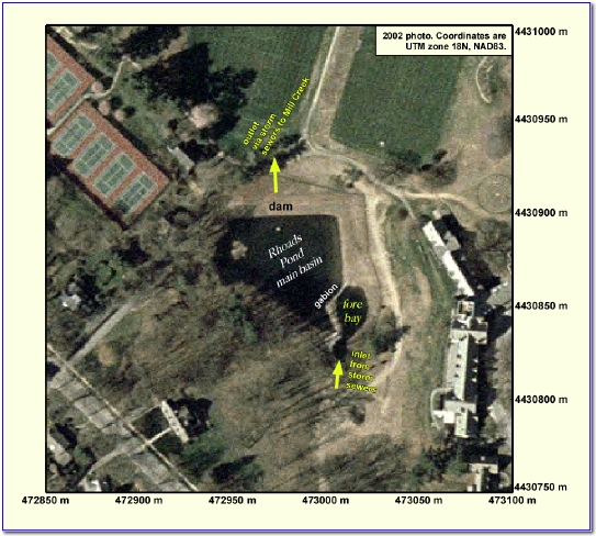
Aerial Map of Rhoads Pond at Bryn Mawr College
Image Provided by Dr. D.Barber
Geology Dept. BMC.
|